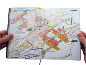
 Image: Cities Without Ground: A Hong Kong Guidebook by Adam Frampto
- How is a city conceptualized, drawn, and read?
The city in the map is conceptualised through its main modes of transport, such as corridors, escalators, roads and tunnels are represented in the map with only labels and vague boundaries and shapes to represent the area’s buildings.
The map is read as a 2D isometric drawing, with a parallel projected view of the spaces, the different levels are represented by its colour codes. The map can be read from left to right, or top to bottom, all the information needed to traverse from place to place is presented to the user.
- From reading maps, what can we learn from how people live and navigate the city?
Since the map heavily focuses on the transportation and traffic flow of the area, we learn that this is probably a high-traffic place for vehicles and people. The verticality in this map is also emphasized with its colour-coded levels, which tells us that people live and navigate the city by moving upwards and downwards.
- What types of narratives (“spatial stories”) do they present?
The numerous transportation services and routes to walk on showcased in the map represents the narratives of the working people, those who commute to the business hubs in the area.
Kuang Yi Chin
3035660897
Good attempt to unpack the map in Frampton’s book, which is already post-analysis. But does the typical traffic map really represents the narratives of the working people or rather, does it dictate/determine a common narrative? Besides the purpose of navigation, what does a map do for and to its user?
What do you think is the main difference in the methods of navigation between using a map (which has been designed by an institution (e.g. government or corporate) and asking a passerby? Can you tell from de Certeau’s suspicion (even dislike?) for the map or any instrument of institutional power from his text? Why is he advocating for individuals to walk and for telling stories? As resistance to…? To what extent do the maps in Cities without Ground attempts to make visible the system of power of control and surveillance that are inherent in a map/directory/plan?